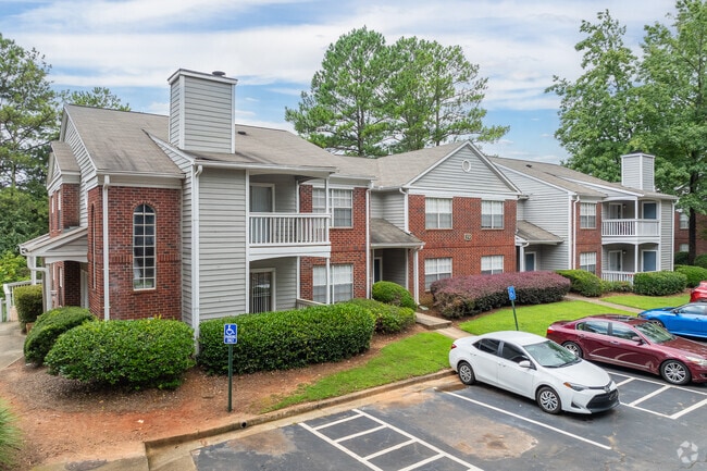
Property Record
3100 Sweetwater Rd, Lawrenceville, GA 30044


NEARBY LISTINGS FOR SALE OR LEASE
-
-
View all Lawrenceville listings for sale on LoopNet.com
Property Detail
3100 Sweetwater Rd
Atlanta-Sandy Springs-Roswell, GA
Sweetwater
6-205-016
SWEETWATER ROAD
Apartment
Gwinnett
AE
Georgia
13135C0085F
180
2025
35.04 AC
2025
Outer Gwinnett County
050541
Atlanta
350,422 SF
DEMOGRAPHICS near 3100 Sweetwater Rd
1 Mile
3 Mile
5 Mile
2024 Total Population
18,910
109,240
259,090
2029 Population
19,814
113,998
269,957
Pop Growth 2024-2029
+ 4.78%
+ 4.36%
+ 4.19%
Average Age
34
35
36
2024 Total Households
7,479
39,148
88,948
HH Growth 2024-2029
+ 4.93%
+ 4.38%
+ 4.25%
Median Household Inc
$48,673
$53,406
$61,583
Avg Household Size
2.50
2.70
2.80
2024 Avg HH Vehicles
2.00
2.00
2.00
Median Home Value
$198,481
$254,695
$275,918
Median Year Built
1993
1994
1992
Nearby Places
Map Layers
Map Styles
 Street
 Aerial
- Restaurants
- Banks
- Shops
- Fitness
- Groceries
PUBLIC TRANSPORTATION
AIRPORT
Hartsfield - Jackson Atlanta International
DRIVE
WALK
Distance
Hartsfield - Jackson Atlanta International
47 min
33.9 mi
Freight Ports
Georgia Ports - Savannah
DRIVE
WALK
Distance
Georgia Ports - Savannah
303 min
268.8 mi
Nearby Properties
Address
Land Use
TOTAL SIZE
Lot Size
Zoning
Address
Land Use
TOTAL SIZE
Lot Size
Zoning
1,457,980 SF
98.78 AC
MUR
Address
Land Use
TOTAL SIZE
Lot Size
Zoning
594,977 SF
47.90 AC
RM13
Address
Land Use
TOTAL SIZE
Lot Size
Zoning
508,494 SF
38.74 AC
RM13
Address
Land Use
TOTAL SIZE
Lot Size
Zoning
563,525 SF
47.80 AC
RM13
Address
Land Use
TOTAL SIZE
Lot Size
Zoning
628,779 SF
97.15 AC
M1
Address
Land Use
TOTAL SIZE
Lot Size
Zoning
1,588,972 SF
112.95 AC
C2
Address
Land Use
TOTAL SIZE
Lot Size
Zoning
761,929 SF
65.19 AC
RM13
Address
Land Use
TOTAL SIZE
Lot Size
Zoning
441,836 SF
35.71 AC
RM13
Address
Land Use
TOTAL SIZE
Lot Size
Zoning
684,224 SF
77.07 AC
OI
Address
Land Use
TOTAL SIZE
Lot Size
Zoning
461,985 SF
56.76 AC
RM10
Address
Land Use
TOTAL SIZE
Lot Size
Zoning
365,821 SF
17.08 AC
RM24
Address
Land Use
TOTAL SIZE
Lot Size
Zoning
356,984 SF
24.89 AC
PUD
Address
Land Use
TOTAL SIZE
Lot Size
Zoning
425,597 SF
49.61 AC
RM13
Address
Land Use
TOTAL SIZE
Lot Size
Zoning
357,946 SF
30.92 AC
RM
Address
Land Use
TOTAL SIZE
Lot Size
Zoning
393,913 SF
25.93 AC
RM13
Address
Land Use
TOTAL SIZE
Lot Size
Zoning
444,605 SF
37.43 AC
RM
Address
Land Use
TOTAL SIZE
Lot Size
Zoning
348,681 SF
35.52 AC
RM10
Address
Land Use
TOTAL SIZE
Lot Size
Zoning
439,676 SF
42.88 AC
RM13
Address
Land Use
TOTAL SIZE
Lot Size
Zoning
450,815 SF
45.79 AC
RM10
Address
Land Use
TOTAL SIZE
Lot Size
Zoning
464,756 SF
33.96 AC
RM13
Address
Land Use
TOTAL SIZE
Lot Size
Zoning
584,576 SF
38.60 AC
RM13
Address
Land Use
TOTAL SIZE
Lot Size
Zoning
419,855 SF
29.83 AC
RM13
Address
Land Use
TOTAL SIZE
Lot Size
Zoning
275,136 SF
44.76 AC
RM13
Address
Land Use
TOTAL SIZE
Lot Size
Zoning
285,038 SF
1.93 AC
MUR
Address
Land Use
TOTAL SIZE
Lot Size
Zoning
503,097 SF
40 AC
RM13
Address
Land Use
TOTAL SIZE
Lot Size
Zoning
470,856 SF
34.99 AC
RM13
Address
Land Use
TOTAL SIZE
Lot Size
Zoning
340,573 SF
22.12 AC
RM13
Address
Land Use
TOTAL SIZE
Lot Size
Zoning
314,338 SF
28.83 AC
RM13
Address
Land Use
TOTAL SIZE
Lot Size
Zoning
361,593 SF
13.35 AC
RM24
The World's #1 Commercial Real Estate Marketplace
Connect with us
© 2026 CoStar Group
The information above has been obtained from sources believed reliable. While we do not doubt its accuracy we have not verified it and make no guarantee, warranty or representation about it. It is your responsibility to independently confirm its accuracy and completeness. Any projections, opinions, assumptions, or estimates used are for example only and do not represent the current or future performance of the property. The value of this transaction to you depends on tax and other factors which should be evaluated by your tax, financial, and legal advisors. You and your advisors should conduct a careful, independent investigation of the property to determine to your satisfaction the suitability of the property for your needs.